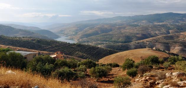


Mountains of the Sultanate of Oman
The high mountain peaks and peaks found in the lands of the Sultanate of Oman have baffled geologists, in addition to the abundance of sand dunes that extend over vast areas. There has always been a question about the origin of the formation of this region of the world, until those interested in exploratory geology decided to study these formations that took place millions of years ago.
Mountain formation in the Sultanate of Oman
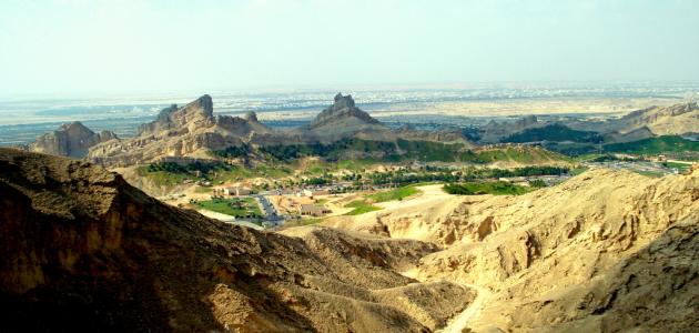
The Omani Geological Society worked with a technical team from the Omani Ministry of Information to study the formation of mountains in the Sultanate of Oman. They indicated that the Hajar mountain range, which is located in the northern side of the Sultanate, dates back to its height for four or six million years, no more, and it is still at A growth rate not exceeding two millimeters per year.
Scholars have pointed out that in the lower part of this chain lies the Green Mountain. They found ice rocks that were formed seven hundred million years ago, and they said that the oldest of these rocks are located in the eastern side of Oman, where Mount Qahwan is. The age of these rocks was determined by radioactive elements in the rocks, as is the case in dealing with igneous rocks, as for sedimentary rocks. It was dealt with by analyzing the age of the fossils found in it.
Geology of the Omani land
The location of Oman is on the far southeastern side of what is called the Arabian continental plate, which is one of the fourteen plates that formed the Earth. The Omani plate is separated from the rest of the plates by boundaries and grooves formed in the interior of the Earth.
Read also:The importance of the Strait of GibraltarThe heat that the Earth stores in its interior has generated enormous thermal currents, as the plates move annually at a rate of four millimeters, and these currents are what cause the plates to diverge from each other in the border areas, but they affect their overlap in other places, and these movements constitute the entire responsibility. From the emergence of mountains, in addition to earthquakes and volcanoes, which caused the shifting of continents, we find that Oman has moved over the ages, like the rest of the land on Earth, to settle in its current place.
The Arabian plate was formed when various land masses coalesced, and that was nine hundred million years ago, when volcanic activity on Earth was at its peak. This appears in the northeastern side of Oman, where Jabal Qahwan is located, which is considered one of the oldest volcanic rocks ever in the Sultanate. Which turned out to be eight hundred and fifty years old, according to analyzes of radioactive elements.
Igneous rocks also appear more extensively in the Wilayat of Mirbat, as igneous barriers were found that penetrate vertically into the older rocks in the granite region, and they are also found in the Wilayat of Mahut.
As the continental plates rose, they were exposed to weather factors, such as winds and differences in temperature, especially erosion as a result of rainfall, and also to the movement of ice blocks. This led to the deposition of rock fragments, where layers of sedimentary rocks were formed.
Read also:Where is Mount Uhud located in the city?Five hundred and twenty million years ago, the land in Oman gradually rose, and this was as a result of the collision with the Indian subcontinent, depositing a group of rocks in Oman, known as the Haima rocks, which are, as geologists described them, from successive sea and land deposits in the region, which formed oil and gas in Al-Haqf. And also in Muqrat.


