Sarawat Mountains
The Hijaz Mountains are considered the longest mountain range in the Kingdom of Saudi Arabia, which is composed of igneous rocks, and some of them are covered with black volcanic calves. The Hijaz Mountains start from the Tihama region to the Najd region, with a length of (1.700) kilometers, and from the Jordanian border (Gulf of Aqaba) to the borders of the Republic of Yemen in the south. They slope steeply toward the west, gradually toward the east, narrow toward the north, and expand as we head toward the south.
Characteristics and topography of the Sarawat Mountains
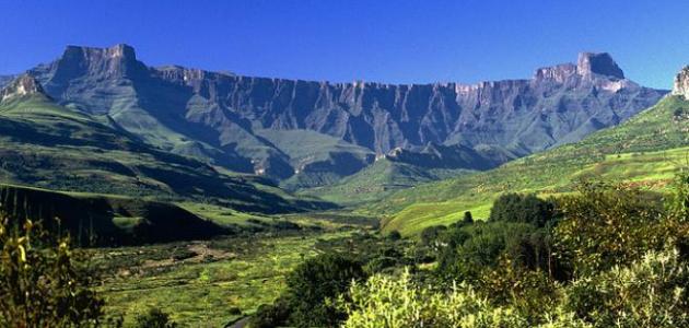
The Sarawat Mountains are characterized by being a parallel mountain range, and there is Mount Al-Sawda, which is the highest peak in the Kingdom of Saudi Arabia, which reaches a height of approximately (3.015) meters above sea level. Many famous valleys also branch out from it towards the Najd region in the east, and Tihama in the west, and among the most prominent are These valleys: Wadi Najran, Wadi Bishah, Wadi Jazan, Al-Aqiq, Shawan, Wadi Taraba, Al-Rumah, and Fatima. In winter, their waters drain either towards the sea, or flow inland. The basins of these valleys are considered an agricultural center because the torrents that flow through them carry with them a lot of water. Silt.
The length of this mountain range inside Saudi Arabia is approximately (1550) kilometers, and its width ranges between (40-240) kilometers. These mountains consist of ancient rocks, some of which date back to the Cambrian era, such as igneous rocks, represented by basalt and granite rocks, and metamorphic rocks such as: schist rocks and gneiss rocks, which are characterized by their strong hardness and resistance to erosion and natural factors. They are also covered by volcanic outcrops called harat, which date back to... The third and fourth geological periods, and its valleys and basins are covered by sedimentary rocks formed at a later period.
Read also:Formation of mountain rangesParts of the Sarawat mountain range
- The southern part: It is called “Al-Sarat Mountains” and extends from the borders of Yemen in the south to the city of Taif towards the north, and its height reaches between (800-3000) meters above sea level, and is divided into sections:
- Sarat Anz Mountains: which overlook the Abha region.
- Sarat Al Hajar Mountains.
- Sarat Nah Mountains.
- Sarat Zahran and Al-Har mountains.
- Sarat Bajila Mountains.
- Sarat Bani Shababa Mountains.
- Sarat Al-Taif Mountains: which overlook Mecca.
- The middle part: It is the Hijaz mountain range, and it was called that because it detains the Najd region from the Tihama region. It extends from Taif to Medina, and among its mountains we mention: Mount Al-Nudra, Mount Al-Dabagh, Mount Ral, Mount Shamansir, and Mount Radwa.
- The northern part: This part is called “Madin Mountains,” which contains many high mountains whose height exceeds (2000) meters above sea level, such as: Jabal al-Lawz, Qayhan, and Jabal al-Qalloum.


