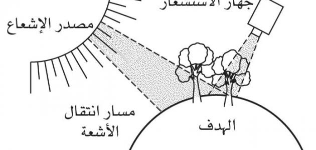


Remote Sensing
Recently, a great global interest has emerged in remote control monitoring devices in areas that are difficult for humans to access, and this is represented in what is called remote sensing science, which is involved in many areas of life, and this scientific field is represented in surveys and recording of information, data and images that It captures the surface of the globe, including land and water, by means of imaging via satellites, spy devices, as well as devices that detect reflected electromagnetic waves that are installed on aircraft designated for remote sensing operations. security, as well as interference in economic, environmental, and space affairs, and below we will present many applications of remote sensing science on the ground represented in the following:
remote sensing applications
- Remote sensing science mainly serves the agricultural field, by predicting the amount of agricultural production, as well as monitoring diseases that affect trees, plants, and soil, and monitoring the degree and extent of desertification, and is greatly useful in monitoring forest fires, which are difficult to access and photograph. .
- It is involved in the field of geology, including the study of all layers of the earth and knowledge of the extent of cracks and others, through geological maps and the discovery of volcanic areas, as well as contributes to the search for natural resources and raw materials needed for industries.
- It is used to study and determine the degrees of pollution to which water bodies are exposed. It also designs maps in which it accurately determines the locations of water resources, including groundwater, and monitors areas where floods are likely to occur.
- It provides very accurate maps in all fields and is particularly useful in addressing places that suffer from environmental pollution in general, in terms of monitoring the extent of air pollution, especially with smoke and factory waste, and waste pollution.
- It helps in providing protection and security for countries, whether from conflicts, wars, and attempts at external control, especially through the air, or protecting antiquities from thefts that may be exposed to palaces, castles, and others.
- It is widely applied in the areas of forecasting natural disasters or disasters whose occurrence is behind human practices and activities, whether those related to earthquakes, volcanoes, tsunamis, and floods of all kinds, or those that result from wars, atomic and nuclear explosions, fires, volcanoes, etc., and thus control and control it.
- It is possible to greatly benefit from this scientific field in the field of glaciers, which is represented in following up the glacial areas, the rate of melting of the accumulated snow, the places of landslides, and others.


