Niger River
It is the third longest river in the African continent, after the Nile and the Congo. It is the longest in West Africa, and the amount of water that passes through it annually exceeds any other African river except the Congo. The course of the Niger River was discovered by the Scot Mungo. Park in the late eighteenth century.
The area in which the river is located was known in the past as the country of Sudan, so the Arabs called the river the Nile of Sudan, and the current word Niger means black in Latin.
Geography of the Niger River
Upstream and downstream countries
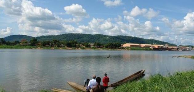
The Niger River begins in the south of the state of Guinea, near the border with Sierra Leone, and then takes its course in a northeasterly direction until the state of Mali, and from there the course turns to the southeast to cross each of the countries of Niger, Benin, and Nigeria, respectively, to finally empty into the Gulf of Guinea in the Atlantic Ocean.
The sources and course of the river
- The river originates from a plateau called Fouta Djallon after the confluence of several tributaries coming from Guinea, Burkina Faso, and Ivory Coast, and takes a northeastern direction, heading to Mali, to pass through the area known as the inner delta of the river. It is a group of channels and shallow lakes on mainly sandy soil, which flood in winter to form a maze of swamps in which the river loses about a third of its water between absorption in the soil and evaporation.
- After the river passes the inner delta region, it begins to turn towards the southeast in what is known as the Niger Ring, crossing an area of desert land across the Nigerian border after receiving large quantities of water from tributaries originating in both Niger and Benin. Despite this, the river is exposed to water loss due to high evaporation rates in that area. Region.
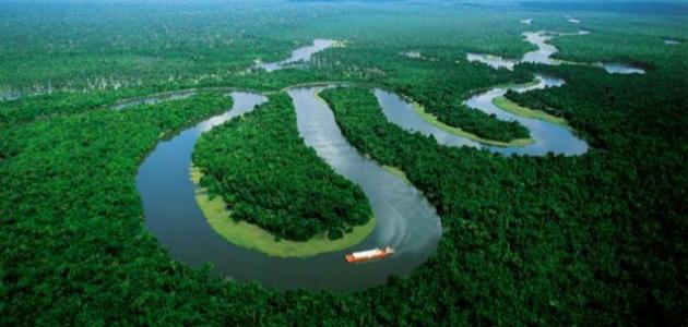
- In Nigeria, the river meets its most important tributary, which is called the Benue River, along with other tributaries coming from Cameroon, characterized by the slope of its lands. They form what is known as the Niger Delta, which is the largest delta on the continent of Africa, and its area is equivalent to more than seven percent of the area of Nigeria. This delta is characterized by the presence of valid channels. For navigation, in addition to the presence of swamps and coastal lakes, this region is also one of the most important regions in the world in the production of oil and natural gas. Nigeria is the richest country on the continent in terms of oil production, in addition to nearly half of the continent’s natural gas production.
- There are many commercial and tourist activities practiced on the banks of the Niger River, such as: power generation projects, fisheries, in addition to the vast areas of agricultural land that owe their existence to the Niger River.


