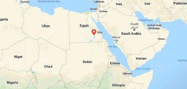
Nile River Basin
The term “Nile Basin Countries” refers to the group of African countries through which the Nile River passes, and they are as follows:
أوغندا
Uganda is considered one of the landlocked countries, and it is located in the eastern part of the continent of Africa along the equator line, and it shares its borders with a group of countries, namely: Kenya, South Sudan, and the Democratic Republic of the Congo, in addition to Rwanda and Tanzania. Uganda has a tropical climate that tends to It is dry in the northern regions, and wet in the southern regions, and it is indicated that it includes many diverse terrains, including Lake Kyoga, Lake Albert, and Lake Victoria, in addition to mountainous areas such as Mount Stanley of the Rwenzori mountain range, plateaus, rain forests, and others. Uganda has many tourist areas, such as: Keppel Forest National Park, Queen Elizabeth Park, Magahinga Gorilla National Park, archaeological museums, and others.
Ethiopia
Ethiopia is considered the largest landlocked country in the world in terms of population, and it shares its borders with Eritrea, Djibouti, Somalia, and Sudan, in addition to South Sudan and Kenya, and it has many terrains such as mountains, plateaus, and valleys, in addition to deserts and forests. Tropical rivers and rivers, the most important of which is the Blue Nile, which is one of the tributaries of the Nile River. Ethiopia also includes some areas that attract tourists around the world, such as the historical city of Aksum, which has been included in the list of UNESCO World Heritage Sites, in addition to To churches, cemeteries, national parks and more.
Read also:Where does the Tigris and Euphrates rivers originate from?Eritrea
Eritrea is considered one of the countries of the Horn of Africa, and it shares its borders with Sudan from the western side, with Ethiopia from the southern side, and with Djibouti from the southeastern side, in addition to the Red Sea from the eastern and northeastern side, and it is considered the first country to announce its designation of the entire coastline For its land as an environmental reserve, it is noteworthy that it includes a group of small islands and coral reefs, and it also includes some interesting sites, such as the Asmara Cathedral, historical cities, the National Martyrs Park, and others.
Sudan
Sudan is located in the northern part of the continent of Africa, bordered by Egypt on the northern side, the Red Sea on the northeastern side, Eritrea and Ethiopia on the eastern side, in addition to South Sudan on the southern side, the Central African Republic on the southwestern side, Chad on the western side and Libya on the The northwestern side, which is located in the Nile Valley, as the river divides it into two halves, the eastern half and the western half, and it is noteworthy that it is considered the third largest African country and the sixteenth in the world.
Democratic Republic of the Congo
The Republic of the Congo is located in the region of the African continent that lies south of the Sahara Desert on the equator. It is characterized by its hot and humid tropical climate throughout the year. It is famous for its rainforests that cover about 70% of its land. It is famous for its coastal plains along the coast of the Atlantic Ocean, and mountains Highlands and rivers, in addition to hosting different types of wild animals.
Read also:Lakes of the Republic of EgyptBurundi
Burundi is located in the eastern part of the African continent, and shares its borders with the Democratic Republic of the Congo, Rwanda, and Tanzania. National parks, thermal waterfalls, and more.
Tanzania
Tanzania is located on the eastern side of the African continent, bordered on the northern side by Kenya and Uganda, on the western side Rwanda, Burundi and the Democratic Republic of the Congo, and on the southern side it overlooks Zambia, Malawi, Mozambique, and the Indian Ocean from the eastern side, as it includes A group of islands such as Zanzibar and Pemba, in which the highest point in the continent of Africa is located: the Kilimanjaro Mountains, and it is noteworthy that it ranks thirteenth as the largest African country, and thirty-first in the world.
رواندا
The state of Rwanda is located in the central region of Africa, at an altitude of about 914 meters above sea level, and includes many diverse terrains, such as forests, plains, and rivers, in addition to mountains and lakes, and shares its borders with Uganda from the northern side, and Tanzania from the side east, and Burundi from the south, in addition to the Democratic Republic of the Congo from the west.
كينيا
Kenya is located in the eastern part of Africa on the equator line and along the coast of the Indian Ocean, and is bordered by Tanzania from the southern side, and Uganda from the western side, in addition to the state of South Sudan from the northwestern side, and Ethiopia from the northern side and Somalia from the northeastern side, and includes peaks Big ones like Mount Kenya, Mount Elgon, lakes like Lake Turkana and Magadi, not to mention rivers like the Galana and Tana.
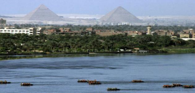
Read also:Where does the Orontes River originate from?Egypt
Egypt is located in the northeastern part of Africa, and a small part of it extends in the southwestern part of Asia, and shares its borders with Libya, Sudan, Egypt and the Gaza Strip, in addition to Jordan and the Kingdom of Saudi Arabia across the Gulf of Aqaba.


