

Africa
The continent of Africa is considered the second largest continent in the world, with an area of about thirty million square kilometers, and this continent is characterized by a multiplicity of civilizations, religions and cultures. Other than Arabic, in which the English, French, Swahili and other languages prevail, and in addition to the multiplicity of civilizations, its terrain also multiplies, which we will mention in this article.
Landforms of the continent of Africa
plateaus
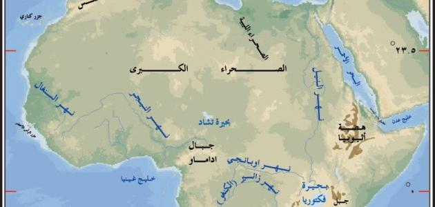
The topography of the continent of Africa is dominated by a plateau character, as its lands consist of a number of major plateaus, the most important of which are: the Great African Sahara Plateau, which extends to the north of the continent, which is considered the largest plateau in the world by area, in addition to the plateau of Ethiopia located in the east of the continent, where there is a plateau of equatorial lakes in the center In the east of the continent, the “Al-Fald” plateau extends in the south, and deserts make up a large proportion of the area of these plateaus, such as the Kalahari Desert, Namibia, and the Great African Desert.
Mountains
There are two mountain ranges on this continent:
- The Atlas Mountains range: It extends in Morocco, Algeria, and Tunisia, that is, in northwest Africa, and its height ranges between 1800 m and 2500 m above sea level.
- Scattered mountain masses: the most famous of which is Mount Kilimanjaro, which is the highest mountain on the continent of Africa. There are also the Tibesti Mountains, the Hakar, the Oweinat, and the Drakensberg.
It should be noted that Mount Kilimanjaro is considered the highest mountain in Africa, which rises to 5895 meters above sea level, and is located in the equator region in the state of Tanzania.
Read also:areas of water useplains
Plains in Africa are divided into two types:
- Coastal plains: They extend along the coasts of the Mediterranean Sea in the north of the continent, and are characterized by their low breadth as a result of the approach of the Atlas mountain ranges to the Mediterranean Sea, whose climate is described as moderate. The coastal plains also extend along the coasts of the Atlantic and Indian oceans.
- Floodplains and rivers: The floodplains extend along the main rivers of the continent, such as: the Nile River, which is the longest river, with a length of 6695 km, the Congo River, the Niger River, the Orange River, and the Zambezi River in which there are Victoria Falls located on the border between the countries of Zambia and Zimbabwe. These rivers are used for irrigation, electric power generation, inland navigation, and fishing.
lakes
There are many lakes in the continent of Africa, the most important of which are: tropical lakes such as Lake Victoria, in addition to Lakes Chad and Tana.
Read also:How do we conserve soil?


