Amsterdam site
The city of Amsterdam, the capital of the Netherlands, is located in the west of the country in the southern part of the province of North Holland, as bodies of water separate it from the northern part of the province, and on the other hand, the capital Amsterdam covers the areas between Zefang to Heimskerk, and from Haarlemmermeer to Othorn, and from Hilversum to Almere, as for the coordinates of the geographical location, Amsterdam is located precisely at longitude 4.895168, and latitude 52.370216.
The strategic importance of the Amsterdam site
The strategic location of the city of Amsterdam in particular, and the state of the Netherlands in general, and its location on the front gate of Europe contributed; By making it a good starting point for the European market, and thus contributing to the facilitation of European commercial operations, and easy access to nearly 95% of the best and most profitable consumer markets in Europe in record time within a maximum of 24 hours, whether from the city of Amsterdam or Rotterdam, and strengthened the presence of both the port of A major sea and international airport in the city makes it easy to access from all over the world, and Amsterdam, the commercial and financial capital of the Netherlands, played a vital and historical role in the development of both global trade and finance, in addition to being a center for shipping, logistics, transportation, and home to more than half of all distribution centers American and Asian-European, it thus occupied a prominent position in the European economy in the twenty-first century, and its strategic location also helped facilitate access to a number of other nearby cities and other destinations that showed the importance of this region and the extent of its distinction.
Read also:Where is Addis Ababa locatedTopography of Amsterdam
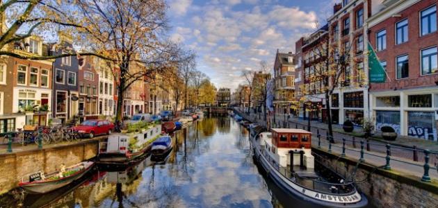
The city of Amsterdam is located at an altitude of 2 meters below sea level, and rivers, canals, floodplains, marshes and low lands surrounded by bridges dominate its topographical terrain, with the Amstel River in the middle, which branches out for a number of channels linked to each other, and which is topped by more than 1500 bridges. As for the southwestern part of the city, it contains a large man-made green forest that constitutes 12% of the city's land area, consisting of a group of parks and nature reserves.
The city of Amsterdam was planned in a modern way at the beginning of the seventeenth century AD, which resulted in dividing the city internally through its network of canals into about 90 islands. IJ, and was known as the canal belt, as three of them contained areas for residential development, which are the Gentleman's Canal (Herengracht), the Emperor's Canal (Keizersgracht), and the Prince's Canal (Prinsengracht), as for the fourth canal, which is farthest from the center, known as the Single Water Canal (Singelgracht), it was dedicated to defense and water management matters.
Amsterdam climate
The marine climate prevails over the general climate of the city of Amsterdam, and this is due to the city being surrounded on three sides by water bodies, and its proximity to the Aegean Sea. For the winter in Amsterdam, it will be moderately cold, and record the lowest temperatures around 22.2 degrees Celsius, as the feeling of freezing cold in Amsterdam is rare. As for humidity, it peaks at 1662% in winter, and with regard to precipitation, it reaches 0.6 mm annually. As for snowfall, the height of snow may reach 83 mm, with an average of 838.2 continuous days of snowfall. As for the spring and autumn seasons, they are considered moderate.
Read also:Where is Alaska located?


