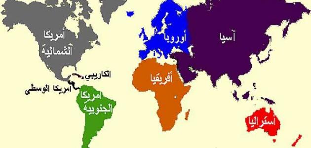

Asia
The continent of Asia is considered one of the largest continents on Earth, and one of the most densely populated, as most of it is located in the eastern and northern hemispheres. It covers 8.7% of the Earth’s surface area, and is inhabited by about sixty percent of the current total world population. This continent is located to the east. From the Suez Canal and the Ural Mountains, and to the south from the Caucasus Mountains, the Caspian Sea and the Black Sea.
The continent of Asia is bordered from the eastern part by the Pacific Ocean, from the southern part by the Indian Ocean, and from the northern part by the Arctic Ocean. There are many differences within this continent and between its regions, and the reason for this is due to ethnic groups, the nature of the environment, diverse cultures, economies, and systems. Governmental relations and historical relations. We will introduce you to the topography of this continent in our next topic.
Topography of the continent of Asia
Mountains
Mountains are an area of the Earth's surface with a height of about 1000 m or more. They appear as a single mass made up of dust and rocks, and have a high peak or a group of chains extending over an area of hundreds of kilometers. Mountains appear on the Asian continent as follows, attached to plateaus and major basins:
- Mountains of the western part of the continent: These are represented by the Turkish Taurus Mountains, and the Zagros Mountains extending in Iraq and Iran.
- Mountains of the central region of the continent: These ranges are among the highest mountains in the world, represented by the Himalayas, which include the highest mountain peak, whose height exceeds about 8848 metres, and is called Mount Everest.
- Mountains of the eastern part of the continent: The mountains of Japan.
plateaus
Plateaus are defined as flat and slightly elevated land, which may be crossed by river valleys or located above them by a group of hills or low basins. They are distributed on the Asian continent as follows:
Read also:How is ozone formed?- The Tibetan Plateau, which is one of the highest plateaus in the world, is located in the center of the Asian continent.
- Anatolian plateau in Türkiye.
- Deccan Plateau in central India.
- Plateau of the Arabian Peninsula.
plains
Plains are a low, flat, and wide area of land whose height does not exceed two hundred meters. They are found on the surfaces of various continents, and are divided into three types: They are: coastal, floodplains, and desert plains. Below, we will introduce you to the plains of the Asian continent:
- Coastal plains: These include some of the plains around the Caspian Sea, and the coastal plains along the coasts of the surrounding seas and oceans on the continent.
- Floodplains: There are the vast northern plains in Siberia, through which many rivers pass and flow into the Polar Ocean, such as: the Ob, Yenisei and Lena rivers, and the plains of the eastern part of the continent, represented by the plains of eastern China, and Manchuria, through which a group of rivers flow; The most important of them are: the Yangtze River, the plains of the Tigris and Euphrates rivers, which flow into the Arabian Gulf, the plain of the Indus River, which drains into the Indian Ocean, and the plain of the Ganges River, which flow into the Gulf of Bengal.


